No Products in the Cart
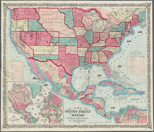
Originally published by Johnson & Browning under the direction of Col. Carlos Butterfield, this reproduction of the hand-colored map features relief shown by hachures and spot heights; depths shown by soundings; and includes illustrations of ships, historical notes, "Table of Distances", inset "Map showing the routes of the ocean steamers", and "Table showing the route of the steamers of the United States and Mexican Mail Steam Ship Line and the various ports in the Gulf of Mexico at which they are to touch, as also the distances between the said ports".
Entered according to Act of Congress in December 1859 by Johnson & Browning to the Clerks Office of the District Court of the United States for the Southern District of New York, this one-sided 28.5"×24" satin-laminated paper wall map has its prime meridians at Washington & Greenwich and covers W 125⁰--W 64⁰ & N 49⁰--N 5⁰ at a scale ca. 1:6,250,000.
The map is encapsulated in heavy-duty 1.7 mil laminate, which makes the paper much more durable and resistant to the swelling and shrinking caused by changes in humidity. Laminated maps can be framed without the need for glass, so the frames can be much lighter and less expensive. Satin Lamination features glare-reducing qualities that provide a soft sheen. A satin finish is best suited for backdrop prints and displays receiving indirect, bright lighting.
 As Seen On TV