National Geographic Maps
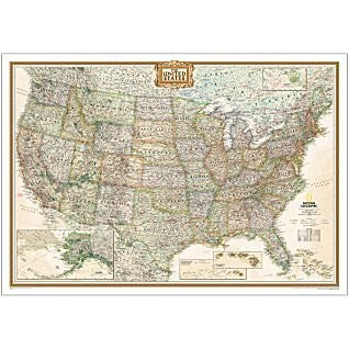
United States of America Classic Political Enlarged Wall Map Dry Erase Laminated
The signature Classic-style United States map uses a bright, easy-to-read color palette featuring blue oceans and stunning shaded relief that has been featured on National Geographic wall maps for over 75 years. All 50 States are featured including insets for Alaska and the Hawaiian Islands. An inset demonstrating the relative size of Alaska is shown as well. All major cities, transportation routes, State boundaries, National Parks, inland waterways, and mountain ranges are clearly displayed and labeled. It is truly an iconic map that never goes out of style.
Enlarged maps provide an immersive experience in any home or office environment. The exceptional cartography is even easier to appreciate at the larger size. The map is encapsulated in heavy-duty 1.7 mil laminate which makes the paper much more durable and resistant to the swelling and shrinking caused by changes in humidity. Laminated maps can be framed without the need for glass, so the frames can be much lighter and less expensive.
Dry Erase Lamination is a specialty laminate that allows for dry-erase markers to be used on the finished print and erased as desired. This dry-erase laminated map can be marked up with dry-erase markers, sticker dots and arrows, or graphic tape for locations, areas, and zones.
- Map Scale = 1:2,815,000
- Sheet Size = 69.25" × 48"