Kappa Map Group
United States Large Scale Wall Map
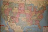
Full color commercial wall map of the United States, at a scale of 1-inch = 40 miles, with the following features: all state and interstate highways, freeways, state lines, all states in different colors, cities and towns, rivers and lakes, national forests and parks, military installations, highway mileages between intersections, Indian Reservations, mountain ranges, Longitude and Latitude lines and time zone boundaries. Map also includes portions of northern Mexico and southern Canada. Map insets of Alaska, Hawaii and Puerto Rico are included. The map is published 77-inches by 54-inches in size, lithographed in 8 colors on 80-pound stock, with top and bottom rails, and is protected with a non-glare matte finish so it is both markable and washable.
- 7129271UR
- 77"×54"